GREEN BOUNDARIES, REAL STAKES: INSIDE UGANDA’S BUDONGO–MASEGE FOREST RESTORATION DRIVE
Uganda is redrawing the line between conservation and encroachment with a 96km “living boundary” across Budongo and Masege forests. Through restoration, community engagement, and strategic partnerships, the project is securing ecosystems while creating livelihoods,
offering a bold model for sustainable forest management in the Albertine Rift.
In Uganda’s Albertine Rift, where biodiversity meets growing human pressure, a new kind of line is being drawn—quietly, deliberately, and with long-term intent.
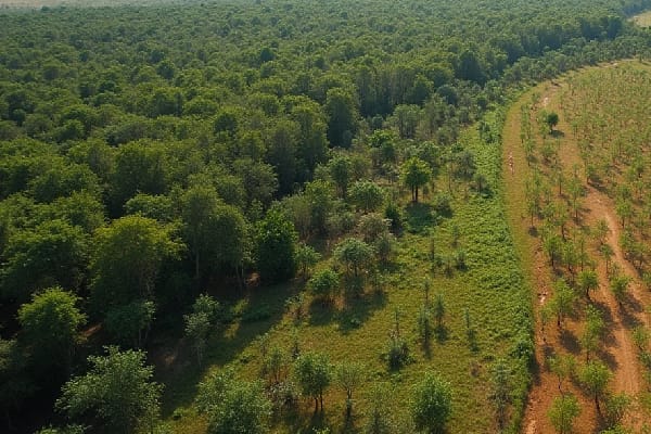
The Budongo–Masege Forest Boundary Planting and Restoration Project is redefining conservation by turning forest boundaries into living systems. Instead of relying solely on maps or concrete markers, the project is physically reshaping how forests are protected—using trees to mark, restore, and defend.
At the centre of this effort is Muloopa Hassan Byakatonda, Executive Director of the Uganda Forest Conservation Group, who sees the initiative as both urgent and transformative. “This is not just about planting trees,” Byakatonda says. “It is about creating a system that secures forest boundaries, restores degraded ecosystems, and empowers communities to take ownership.”
The project spans approximately 400 hectares across Budongo Central Forest Reserve and Masege Forest Reserve. Its most striking feature is a 96-kilometre living boundary, constructed using three parallel lines of indigenous trees planted at carefully measured intervals.
This approach is as practical as it is symbolic.
“We are moving away from invisible boundaries,” Byakatonda explains. “When a boundary is visible and ecological, it becomes easier to respect and protect.”
But the work goes beyond marking territory. In Budongo, 10 hectares of degraded forest are being restored through enrichment planting and assisted natural regeneration. In Masege, 20 hectares are undergoing restoration, alongside the reopening of 15 kilometres of boundary and reinforcement with tree planting and permanent markers.
The urgency behind the project is clear. The Albertine Rift is under increasing strain from multiple fronts—industrial activity, population growth, and land-use pressure.
“We are responding to real and compounding threats,” Byakatonda says. “Encroachment, illegal logging, and expanding agriculture are already affecting these landscapes.”
He also points to the broader context of oil and gas development linked to TotalEnergies EP Uganda, which has intensified the need for proactive biodiversity safeguards.
“The goal is to secure ecosystem integrity before the damage becomes irreversible.”
At the heart of the boundary strategy is Mvule, an indigenous species chosen for its strength and longevity.
“Mvule is highly visible, long-living, and structurally strong,” Byakatonda explains. “It creates a boundary that will stand for decades.”
Beyond its durability, the tree supports biodiversity and contributes to long-term ecosystem services. If managed well, the green boundary itself could evolve into an eco-tourism asset.
“It is both a marker and an investment in the future.”
Implementation on the ground is deliberately community-driven. Through Collaborative Forest Management (CFM) groups, local communities, especially women and youth, are directly involved in planning, planting, and maintaining the forest boundary. “We are building ownership,” Byakatonda says. “Because conservation only works when communities are part of it.”
Activities range from boundary verification and planting to nursery management and continuous engagement. Forestry professionals oversee the process, ensuring standards are met while communities remain central to execution.
Seedlings used in the project are sourced from certified nurseries and project-established systems, with strict quality controls in place. “We work with verified seed sources and enforce best nursery practices,” Byakatonda notes. “Every seedling must meet the standard.” He also clarifies concerns about the mention of 40,000 seedlings:
“There is no shortage. That was an opportunity to involve local nursery operators, improve quality, and strengthen the supply chain.”
The project is funded by TotalEnergies EP Uganda and implemented in collaboration with the National Forestry Authority, ensuring both financial backing and regulatory oversight.
Launched on February 24, 2026, the project is designed to run for 12 months, with planting aligned to Uganda’s rainy seasons to maximise survival.
But as Byakatonda points out, planting is only the beginning.
“The real work is ensuring survival.”
A robust Monitoring, Evaluation, and Learning (MEL) framework supports this through routine assessments, replanting where necessary, and continuous maintenance.
“We track, we learn, and we adapt. That is how sustainability is achieved.”
For surrounding communities, the impact is already tangible. The project is creating jobs, building skills, and opening pathways for climate-smart enterprises.
“Conservation must deliver value,” Byakatonda says. “When livelihoods improve, forests are protected.”
As the lines of trees take root across Budongo and Masege, they represent more than boundaries. They signal a shift, from reactive conservation to proactive design.
“This project sets a model,” Byakatonda concludes. “It shows that we can protect forests, restore ecosystems, and support communities at the same time.”
Econews Editorial Insight: In a region where pressure on natural resources continues to rise, the Budongo–Masege project offers something rare, clarity.